A day in the life of a wetland scientist

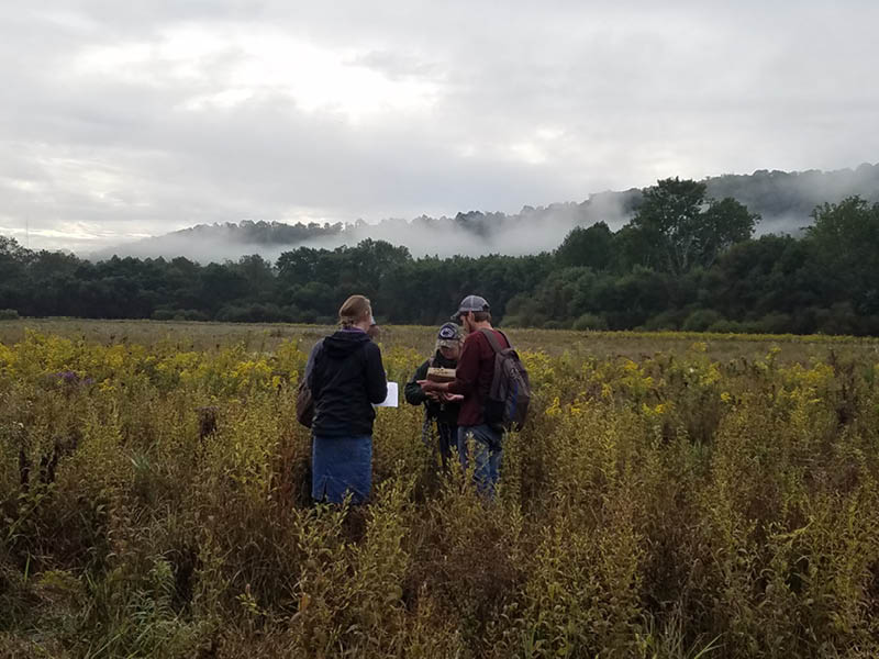
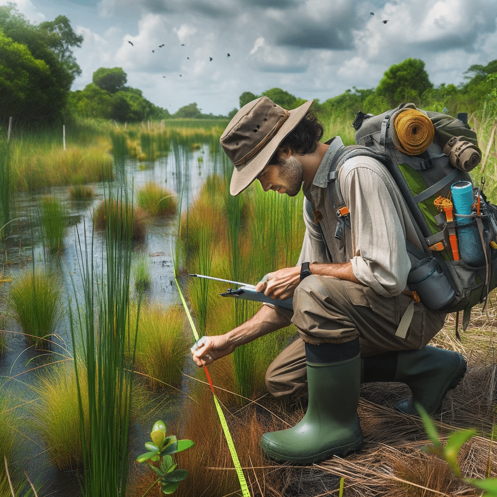
In the field, the wetland scientist engages in a variety of specialized tasks, including soil sampling to identify hydric soils, conducting thorough vegetation surveys, and assessing wetland hydrology through both direct and indirect means. These activities require a keen eye for detail, extensive knowledge of wetland ecosystems, and the ability to work effectively in challenging outdoor conditions. Additionally, the role involves meaningful interactions with local communities, landowners, and regulatory bodies, emphasizing the importance of wetlands in ecological balance and sustainable land use.

The day of a wetland scientist is not just about fieldwork; it also involves critical analysis and documentation back at the office or lab. Here, the scientist delves into data interpretation, report writing, and consultation with environmental experts, ensuring that their findings contribute to broader conservation efforts and comply with environmental regulations. The narrative also emphasizes the importance of continuous learning and professional development in the field of wetland science. This commitment to staying abreast of the latest research, technological advancements, and regulatory changes is vital for effective wetland management and protection.

  • Early Morning Research and Preparation: The scientist’s day begins with reviewing satellite images, wetland delineation protocols, and local environmental regulations. They ensure that all their equipment, including soil coring tools and water quality kits, is ready for the day.
  • Travel to the Wetland Site: The journey to the wetland site might be an adventure, often traversing through less-traveled paths. The scientist plans their route, considering the day’s objectives and the logistics of reaching the site.
  • Initial Site Assessment: Upon arrival at the wetland, the scientist conducts an initial survey, looking for visible indicators of wetland boundaries and making preliminary notes.
  • Detailed Wetland Delineation Work: The morning is spent in intense fieldwork, including soil sampling, vegetation identification, and hydrology assessment, to accurately delineate the wetland boundaries.
  • Fun and Exploratory Lunch Break: By midday, it’s time for a well-deserved break. The scientist often takes this opportunity to explore local eateries, enjoying the chance to discover unique and interesting restaurants in the area. This lunch break becomes a mini-adventure, offering a delightful pause from the fieldwork and a chance to savor the local cuisine.
  • Post-Lunch Delineation and Data Collection: After lunch, the scientist returns to the field, possibly revisiting certain areas for additional verification or moving to new sections for further delineation.
  • Community Interaction and Educational Outreach: The afternoon may also include interactions with local communities, landowners, or educational groups, discussing the day’s findings and the importance of wetland conservation.
  • Return to Base for Analysis and Reporting: Back at their office or lab, the scientist analyzes the collected data, begins processing samples, and starts drafting reports based on the day’s delineation work.
  • Consultations and Collaborations: The scientist might consult with environmental agencies or collaborate with colleagues, ensuring that the delineation aligns with regulatory standards and contributes to broader environmental research.
  • Evening Review, Planning, and Networking: The day concludes with a review of the work done, updating project files, and perhaps participating in professional networking activities, staying connected with the wider scientific community.
  • Continued Learning and Research: The scientist spends time in the evening catching up on the latest research in wetland ecology and planning for future professional development opportunities.
  • Relaxation and Personal Time: Finally, the scientist unwinds, reflecting on the day’s work and the culinary adventure they enjoyed at lunch, recharging for the next day’s challenges.

The Swamp School Announces Keap Certified Partnership

ANGIER, N.C., December 19, 2023 (GLOBE NEWSWIRE) – We are thrilled to announce we are teaming up with Keap to help serious entrepreneurs grow. As a Keap Certified Partner, The Swamp School, LLC can provide an exceptional level of consulting, training, and implementation services by joining this community of experts focused on helping small businesses grow.

Keap’s Certified Partner Program provides powerful solutions for small businesses such as web development, copywriting, marketing consultations, and many other professional services. This powerful combination has allowed Keap and its Partners to be dominant forces in the small business success movement.

“The Swamp School has undergone an intensive training program and passed our in-depth qualification standards to become certified,” said Ankur Bhatnagar, VP of partner programs at Keap. “We don’t certify just anyone who wants to join our community – Certified Partners meet our exceedingly high standards to ensure our small business customers are working with only the best. Today we congratulate and proudly welcome The Swamp School to our thriving community of Keap Certified Partners who are helping more small businesses every day get organized and grow.

To learn more about The Swamp School, visit https://swampschool.riversagency.com/.

ABOUT THE SWAMP SCHOOL, LLC

Based in Angier, North Carolina, The Swamp School offers post-secondary/college classes and webinars in wetland assessment, delineation and design, and other topics relating to the management of wetlands. The classes are designed to help environmental professionals enhance their skills and expand their business.

ABOUT KEAP PARTNER PROGRAMS

For more than 20 years, Keap has helped liberate and empower small business entrepreneurs so they can strengthen their families, communities, and the global economy. Keap pioneered the sales and marketing automation software market with its Keap family of products, services to help small business owners market their businesses effectively, and expert coaching. Headquartered in Chandler, Arizona, the company is on a mission to simplify growth for 1 million entrepreneurs worldwide by 2030. Keap is funded by Goldman Sachs, Bain Capital Ventures, Mohr Davidow Ventures, and Signal Peak Ventures.

###
For media inquiries, contact Rivers Agency:
publicrelations@riversagency.com
919-932-9985

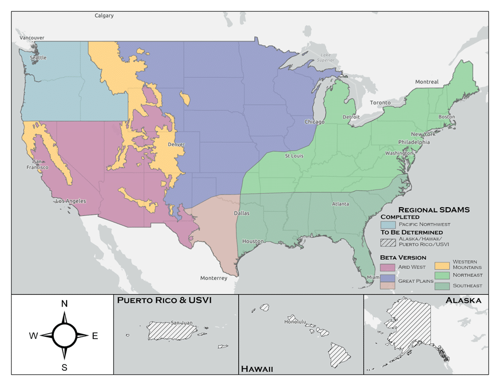
Streamflow Duration Assessment Methods (SDAMs)

The U.S. Army Corps of Engineers (USACE) has developed the Streamflow Duration Assessment Methods (SDAMs), currently in their interim phase, to enhance the management and protection of water resources. This interim phase, reflecting a period of testing and refinement, is crucial for ensuring the accuracy and effectiveness of these methods.

Understanding the Interim Phase of SDAMs

The interim phase of the SDAMs, is a dynamic period where the methods are being field-tested, evaluated, and improved. This phase allows for the incorporation of feedback from various stakeholders, including environmental scientists, water resource managers, and policy makers.

The Role and Importance of SDAMs

Streamflow Duration Assessment Methods are essential for classifying streams based on the duration and frequency of their flow. This classification is vital for:

  1. Environmental Conservation: Assessing the impact of streamflow on aquatic ecosystems.
  2. Water Resource Management: Informing decisions related to water rights, usage, and allocation.
  3. Land Development: Guiding development projects to minimize adverse effects on water resources.
  4. Regulatory Compliance: Aiding in adherence to environmental regulations, such as the Clean Water Act in the U.S.

Implementation Strategies During the Interim Phase

During this interim phase, USACE employs various strategies:

  • Pilot Studies: Conducting field tests in diverse geographical locations to understand the method’s applicability.
  • Stakeholder Feedback: Actively seeking input from users to refine the methods.
  • Data Collection and Analysis: Gathering and analyzing extensive data to validate and improve the methods.
  • Technological Integration: Incorporating advanced technologies such as remote sensing and hydrological modeling.

Challenges and Future Outlook

The interim phase faces challenges like dealing with the impacts of climate change and the need for robust data. Looking ahead, the focus will likely be on:

  • Refining Models: Enhancing the precision and reliability of the methods.
  • Climate Adaptation: Incorporating climate change projections more comprehensively.
  • Expanding Collaboration: Increasing engagement with a broader range of stakeholders.

The U.S. Army Corps of Engineers’ (USACE) Streamflow Duration Assessment Methods (SDAMs) play a significant role in determinations related to the Waters of the United States (WOTUS). WOTUS is a term used in U.S. federal environmental regulations that defines the bodies of water that fall under the jurisdiction of the Clean Water Act (CWA). Understanding this relationship is crucial for environmental protection, water resource management, and compliance with federal laws.

The Role of SDAMs in WOTUS Determinations

  1. Defining Jurisdictional Waters: SDAMs are instrumental in determining whether a particular stream or water body falls under the category of WOTUS. By assessing the duration and frequency of streamflow, these methods help to classify streams as perennial, intermittent, or ephemeral, which is a key factor in WOTUS determinations.
  2. Environmental Regulation Compliance: The classification of water bodies as WOTUS has significant implications for environmental regulation, particularly in terms of permitting, pollution control, and habitat protection under the CWA.
  3. Impact on Land Use and Development: SDAMs influence decisions on land use and development. Projects near water bodies classified as WOTUS might require additional permits and environmental assessments to ensure compliance with the CWA.
  4. Protection of Aquatic Ecosystems: By aiding in the identification of WOTUS, SDAMs contribute to the protection of aquatic ecosystems, especially those dependent on certain streamflow conditions.

Challenges and Complexities in WOTUS Determinations

  1. Changing Definitions and Regulations: The definition of WOTUS has been subject to changes and legal challenges over the years, affecting how SDAMs are applied in regulatory contexts.
  2. Interagency Collaboration: WOTUS determinations often require collaboration between the USACE, the Environmental Protection Agency (EPA), and other federal and state agencies, necessitating a harmonized approach to streamflow assessment.
  3. Site-Specific Assessments: SDAMs need to be adaptable to various geographical and climatic conditions, as streamflow characteristics can vary significantly across different regions.
  4. Incorporating Climate Change Impacts: With changing climate patterns, the assessment of streamflow duration may become more complex, affecting WOTUS determinations over time.

Conclusion

The USACE’s Streamflow Duration Assessment Methods, in their critical interim phase, represent a significant step forward in sustainable water resource management. As these methods evolve, they will play an increasingly important role in protecting and managing water resources effectively for future generations. The ongoing development and refinement during this interim phase, while challenging, are essential for the creation of reliable and universally applicable streamflow assessment tools.

The Streamflow Duration Assessment Methods are deeply intertwined with the determinations of Waters of the United States. They provide a scientific and systematic approach to classifying water bodies, which is fundamental for regulatory compliance, environmental protection, and informed decision-making in land development. As environmental policies and climate conditions continue to evolve, the role of SDAMs in WOTUS determinations remains a key aspect of sustainable water resource management.

The Swamp School Receives Eligibility for Scholarship Funding From the mikeroweWORKS Foundation

December 12, 2023 — The Swamp School is excited to announce a new opportunity for students enrolled in the wetland delineation training program, made possible by the mikeroweWORKS Foundation. In line with the Foundation’s mission to promote hard work and skilled labor, this initiative opens the door for dedicated individuals pursuing careers in environmental science and wetland conservation.

Eligibility for the mikeroweworks.org scholarship has now been extended to include students of The Swamp School, providing a unique opportunity for those passionate about wetland preservation and environmental stewardship. This inclusion reflects the Foundation’s recognition of the crucial role that wetland delineation plays in environmental protection and sustainability.

Students enrolled in The Swamp School’s program are encouraged to apply for this scholarship, which aims to support those who demonstrate a strong work ethic, commitment to their vocational education, and a dedication to their field of study. The scholarship will not only provide financial assistance but reinforce the importance of skilled technical professionals in environmental sciences.

For more information on the scholarship application process, eligibility criteria, and deadlines, students are advised to visit the mikeroweWORKS Foundation’s website at mikeroweworks.org. Additionally, inquiries about the wetland delineation training program should be directed to The Swamp School.

This collaboration between the mikeroweWORKS Foundation and The Swamp School marks a significant step toward fostering the next generation of skilled environmental professionals, ensuring the preservation and responsible management of vital wetland ecosystems.

Contact:
mikeroweworks.org
swampschool.org

About Mike Rowe and the mikeroweWORKS Foundation

Mike Rowe is an Emmy award-winning TV host, producer, narrator, podcaster, spokesman, best-selling author, recording artist, and America’s leading advocate for the skilled trades. The creator and host of Discovery Channel’s “Dirty Jobs,” Mike has traveled to every state on multiple occasions and worked alongside hundreds of Americans in more than 350 different vocations. As the CEO of the mikeroweWORKS Foundation, he has awarded nearly $7 million dollars in work-ethic scholarships and led a national effort to reintroduce shop classes into high schools.

About The Swamp School – SwampSchool.org

Based in Angier, North Carolina, The Swamp School is a pioneer in delivering comprehensive online and in-person educational experiences tailored for professionals and technicians in the field of wetland science and management. Since its inception in 2002, The Swamp School has been exclusively dedicated to fostering growth and expertise in environmental professionals who are as committed to conservation and stewardship.

The Ivory-Billed Woodpecker: Ghost of the Southern Swamps

Ivory Billed Woodpecker

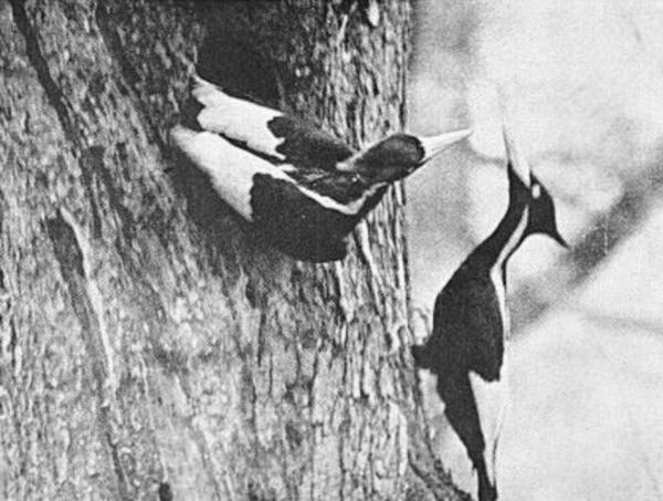
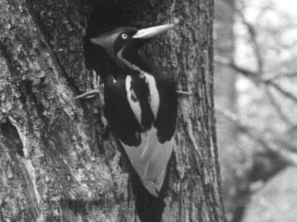
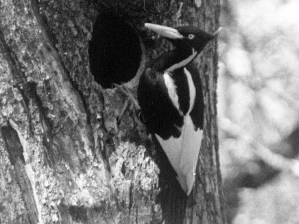
The Ivory-Billed Woodpecker, Campephilus principalis, has long been an enigma wrapped in the moss-draped mystery of the southern United States’ bottomland hardwood forests and swamp lands. Once roaming the vastness of the southeastern forests, it was a bird so distinctive and majestic that its presence was deemed a spectacle of the wild. Known for its striking black and white plumage and a bill as white as ivory, it was not only the largest woodpecker in America but also one of the most iconic avian species ever to grace the forests. However, extensive habitat destruction and hunting have led it to the brink of extinction, and possibly beyond.

Natural History and Significance

The Ivory-Billed Woodpecker was an inhabitant of the primeval forests of the Southeast, relying on vast tracts of old-growth woods where dead or dying trees provided the large insect larvae that constituted its primary diet. These woodpeckers played a critical role in the ecosystem, not only as predators that helped control insect populations but also as ecosystem engineers. Their large nesting cavities, excavated in the trunks of ancient trees, became nurseries for their own young and provided shelter for a plethora of other species.

The cultural significance of the Ivory-Billed Woodpecker is multifaceted. It has been a symbol of the wilderness, a muse for bird watchers and naturalists, and a poignant emblem of loss and the consequences of environmental disregard. The bird’s remarkable size and beauty, coupled with its elusiveness, have etched it into the folklore and heart of the American South.

Image by Arthur A. Allen, Courtesy of the Cornell Lab of Ornithology.

Decline and Presumed Extinction

The decline of the Ivory-Billed Woodpecker was a gradual process accelerated by human actions. The early 20th century was an era of unregulated logging, which decimated the extensive hardwood forests that were the habitat of the Ivory-Billed Woodpecker. These operations did not only reduce the amount of available food but also removed the large, old trees essential for nesting. Furthermore, the bird’s distinctive markings and size made it a target for trophy hunters and collectors, exacerbating its plight.

By the mid-20th century, the species was so rare that it was presumed to be extinct. The last universally accepted sighting was in the 1940s, in the Singer Tract of Louisiana, a large area of old-growth forest that was subsequently logged. The loss of the Ivory-Billed Woodpecker has been a profound one, signaling not only the disappearance of a species but also serving as a harsh reminder of the delicate balance of ecosystems and the far-reaching impact of human activity on the natural world.

Contested Sightings and Conservation Efforts

Over the years, there have been reports and rumors of sightings of the Ivory-Billed Woodpecker, sparking hope that the species may yet cling to existence. The most notable of these was in 2004 when a team of ornithologists from the Cornell Lab of Ornithology reported sightings in the Big Woods region of Arkansas. This announcement triggered a wave of excitement and controversy, as subsequent searches yielded no definitive proof, such as clear photographs or videos, leaving many skeptical.

Despite the lack of conclusive evidence, these reports have fueled a variety of conservation efforts aimed at preserving the habitats that could potentially support a remnant population of the bird. Organizations and government entities have implemented measures to protect large tracts of forestland that could be suitable for the Ivory-Billed Woodpecker, hoping to create a safe haven for these birds if they do indeed still exist. These efforts have also benefited a multitude of other species that share these ecosystems, illustrating a silver lining to the ongoing quest to find the Ivory-Billed Woodpecker.

Reflections on Conservation and the Future

The story of the Ivory-Billed Woodpecker is a poignant narrative that underscores the urgency of conservation. It demonstrates that once a species is pushed to the brink of extinction, the chances of recovery are often slim and fraught with challenges. It also highlights the importance of protecting habitats before they are degraded to the point of being unable to support their native species.

The potential survival of the Ivory-Billed Woodpecker offers a symbol of hope and a call to action. It is a reminder that nature can be resilient if given the chance and that the protection of the environment is an investment in the future of all species, including humans. Whether or not the Ivory-Billed Woodpecker still flits among the shadowed trees of southern swamps, the efforts to save it have ignited a broader conservation movement that continues to grow in importance as we face the ongoing challenges of habitat loss, climate change, and biodiversity decline.

The Ivory-Billed Woodpecker’s legacy is a complex tapestry woven from strands of awe at the natural world, sorrow for what has been lost, and determination to prevent similar fates for other species. The debate over its existence continues to inspire both professional and amateur conservationists to keep searching, keep studying, and most importantly, keep protecting the wild places that remain. Whether it still exists as a living species or has moved beyond the veil into the realm of legend, the Ivory-Billed Woodpecker will forever serve as an icon of the wild and a beacon for conservation. It reminds us of the fragility of life, the consequences of neglect, and the ever-present possibility of redemption through dedicated environmental stewardship.

Image by Arthur A. Allen, Courtesy of the Cornell Lab of Ornithology

The 2024 Wetland Scientist Jobs Outlook: Navigating a Critical Ecosystem’s Future

The Rise of Wetland Science as a Career

As global environmental concerns continue to escalate, the field of wetland science has become increasingly significant. The year 2024 projects a fascinating era for wetland scientists, where their expertise is not only sought after but also crucial for the health of our planet. These scientists are on the front lines of conservation, research, and policy-making, dealing with issues from climate change mitigation to habitat protection and biodiversity conservation.

The Demand for Wetland Scientists in 2024

The job outlook for wetland scientists in 2024 remains robust and growing. With a heightened global focus on environmental sustainability and wetland conservation, wetland scientists are in high demand. Their skills are crucial for:

  1. Assessing Wetland Health: Evaluating the conditions of wetlands, identifying stress factors, and implementing conservation strategies.
  2. Regulatory Compliance: Ensuring that construction, development, and land use comply with environmental laws and regulations, particularly those that protect wetland areas.
  3. Climate Change Mitigation: Understanding the role of wetlands in carbon sequestration and their impact on global climate patterns.
  4. Restoration Projects: Working on the restoration of degraded wetland areas to their natural state, a vital component in preserving biodiversity and maintaining ecosystem services.
  5. Research and Education: Conducting research on wetland ecosystems and disseminating knowledge to stakeholders, policymakers, and the public.

Education and Skill Development

The path to becoming a wetland scientist often begins with a degree in environmental science, ecology, biology, or a related field. As the discipline grows, so does the complexity of the skill set required. In 2024, successful wetland scientists will likely need:

  • Advanced degrees for higher-level positions.
  • Strong background in GIS (Geographic Information Systems) and remote sensing technology.
  • Proficiency in data analysis and modeling software.
  • In-depth understanding of local, national, and international environmental laws.
  • Soft skills such as project management, communication, and stakeholder engagement.

Specialization in wetland science through certifications like the Professional Wetland Scientist (PWS) certification by the Society of Wetland Scientists can also enhance job prospects.

Industry Trends Influencing Job Prospects

Several trends are shaping the job market for wetland scientists in 2024:

  1. Green Infrastructure Projects: The push for sustainable development includes the creation of urban wetlands for stormwater management, requiring wetland scientists for design and monitoring.
  2. Policy and Advocacy: International treaties and national policies focusing on wetland preservation are expanding the role of wetland scientists in policy advisement and implementation.
  3. Private Sector Engagement: Increased corporate responsibility and sustainability goals mean more private companies are hiring wetland scientists for environmental impact assessments and sustainability planning.

Geographical Hotspots for Wetland Science Jobs

Certain regions will likely emerge as hotspots for wetland science careers:

  • Coastal areas affected by sea-level rise and increased storm activity.
  • Urban centers implementing green infrastructure initiatives.
  • Countries with significant wetland biodiversity, such as Brazil, Indonesia, and the Congo Basin, where conservation efforts are critical.

Challenges and Opportunities

The road ahead for wetland scientists is not without its challenges:

  • Funding Constraints: Economic downturns and shifting political landscapes can impact funding for environmental initiatives and research.
  • Technological Advancements: Keeping up with rapid technological changes in data collection and analysis is necessary.
  • Interdisciplinary Collaboration: Working with professionals from other fields, such as urban planners and engineers, is essential for comprehensive wetland management.

Conversely, these challenges bring opportunities:

  • Innovative Solutions: There’s a growing need for innovative approaches to wetland conservation and restoration, which can lead to new job roles and specializations.
  • Public Engagement: Increasing public awareness of wetland benefits can lead to more community-based wetland projects, expanding the roles of educators and citizen science coordinators.
  • International Cooperation: As wetlands are a global concern, there are opportunities for work in international conservation and policy.

Conclusion: A Positive Outlook with a Note of Urgency

The job outlook for wetland scientists in 2024 is generally positive. The urgency to address environmental challenges ensures that wetland scientists will remain in demand. However, it’s a field that requires constant learning and adaptability to new research, technologies, and evolving environmental policies.

For those aspiring to enter the field or continue their wetland science careers, the time is ripe for action. As guardians of one of the world’s most precious resources, wetland scientists not only have the opportunity to pursue a career with significant growth prospects but also to make a tangible difference in the health of our planet.

EPA and the Department of the Army issue Amended Final Rule Defining WOTUS

By Rick Savage – Carolina Wetlands Association

On August 29, 2023, the U.S. Environmental Protection Agency (EPA) and the Department of the Army announced a final rule that amends the January 2023 definition of “waters of the United States” (WOTUS). The amendments conform the January 2023 definition to the U.S. Supreme Court’s decision in Sackett and will take effect immediately upon publishing in the Federal Register (likely to happen within two weeks)To read the pre-publication version of the revised final rule, go to Pre-publication Version of the Final Rule – Amendments to the Revised Definition of Waters of the United States (epa.gov)

While exact details are yet to be digested, the gist of the ruling is becoming clear.  First, the significant nexus rule has been eliminated; so isolated wetlands are not jurisdictional wetlands, meaning they are not protected under the Clean Water Act.  Second, the new rule requires visual evidence of a continuous surface flow between a wetland and navigable water.  This part of the rule can get complicated as to what constitutes visual evidence of continuous surface flow.  I am sure that this will cause a lot of confusion and some developers will say there is no continuous surface flow and impact the wetland with a permit. 

Suffice it to say, this puts wetlands in North and South Carolina in jeopardy. The NC Department of Environmental Quality has estimated about 2.5 million acres of wetland have lost protection in North Carolina and I am sure a similar number in South Carolina.  The NC legislature could have continued to protect these wetlands; however, the recently passed Farm Bill eliminated state protection of isolated wetlands.   

We all need to brace ourselves for a lot of wetland loss and they are the very resource we need to protect our communities from flooding.  I think it is reasonable to expect more communities to get flooded, to have less clean water, and to have reduced climate resilience as well as miss the many other benefits that our wetlands provide. 

So go out an explore a wetland (before it gets developed?).

August 2023 Definition of Waters of the United States

On August 29, 2023 the US EPA and the US Army Corps of Engineers released a pre-publication version of the conforming amendment to the 2023 definition a Waters of the US. I cannot recall ever having seen a “conforming amendment” in all my years working with this issue. In fact, I am not sure it has ever been done before in any circumstance. I expect the next round of challenges to this rule will focus on this.

The final version of this rule is the weakest version of the Waters of the US we have ever had. The amount of wetlands no longer covered by Clean Water Act protections is the lowest it has ever been including the Navigable Waters Protection Rule era. It is also important to note that the Supreme Court Decision that prompted this new rule was a unanimous (9-0) one. All nine justices were in agreement despite popular media decrying it was the right side of the bench that dominated the Decision.

This is a final rule and becomes effective on the date it is published in the Federal Register. There is no public comment period. I am still unclear as to why the agencies are in such a hurry to not regulate wetlands.

Much of the new rule discusses why it is proper to issue a conforming amendment without a public comment period. The rule itself is fairly brief, in that it provides the edits to the existing Biden rule. The rule itself does not merge the two rules together into a single document. They leave that up to you. However, we have done this for you and the total new conforming rule follows. We will also be hosting a webinar on this new rule on September 28, 2023. Hope to see you there!

Title 33 —Navigation and Navigable Waters

Chapter II —Corps of Engineers, Department of the Army, Department of Defense

Part 328 —Definition of Waters of the United States

Authority: 33 U.S.C. 1251 et seq.

Source: 51 FR 41250, Nov. 13, 1986, unless otherwise noted.

§ 328.3 Definitions.

For the purpose of this regulation these terms are defined as follows:

(a) Waters of the United States means:

(1) Waters which are:

(i)  Currently used, or were used in the past, or may be susceptible to use in interstate or foreign commerce, including all waters which are subject to the ebb and flow of the tide;

(ii) The territorial seas; or

(iii) Interstate waters,

(2)  Impoundments of waters otherwise defined as waters of the United States under this definition, other than impoundments of waters identified under paragraph (a)(5) of this section;

(3) Tributaries of waters identified in paragraph (a)(1) or (2) of this section that are relatively permanent, standing or continuously flowing bodies of water;

(4) Wetlands adjacent to the following waters:

(i) Waters identified in paragraph (a)(1) of this section; or

(ii) Relatively permanent, standing or continuously flowing bodies of water identified in paragraph (a)(2) or (a)(3) of this section and with a continuous surface connection to those waters.

(5) Intrastate lakes and ponds not identified in paragraphs (a)(1) through (4) of this section that are relatively permanent, standing or continuously flowing bodies of water with a continuous surface connection to the waters identified in paragraph (a)(1) or (a)(3) of this section.

(b)  The following are not “waters of the United States” even where they otherwise meet the terms of paragraphs (a)(2) through (5) of this section:

(1)  Waste treatment systems, including treatment ponds or lagoons, designed to meet the requirements of the Clean Water Act;

(2)  Prior converted cropland designated by the Secretary of Agriculture. The exclusion would cease upon a change of use, which means that the area is no longer available for the production of agricultural commodities. Notwithstanding the determination of an area’s status as prior converted cropland by any other Federal agency, for the purposes of the Clean Water Act, the final authority regarding Clean Water Act jurisdiction remains with EPA;

(3)  Ditches (including roadside ditches) excavated wholly in and draining only dry land and that do not carry a relatively permanent flow of water;

(4) Artificially irrigated areas that would revert to dry land if the irrigation ceased;

(5)  Artificial lakes or ponds created by excavating or diking dry land to collect and retain water and which are used exclusively for such purposes as stock watering, irrigation, settling basins, or rice growing;

(6)  Artificial reflecting or swimming pools or other small ornamental bodies of water created by excavating or diking dry land to retain water for primarily aesthetic reasons;

(7)  Waterfilled depressions created in dry land incidental to construction activity and pits excavated in dry land for the purpose of obtaining fill, sand, or gravel unless and until the construction or excavation operation is abandoned and the resulting body of water meets the definition of waters of the United States; and

(8)  Swales and erosional features (e.g., gullies, small washes) characterized by low volume, infrequent, or short duration flow.

(c) In this section, the following definitions apply:

(1)  Wetlands means those areas that are inundated or saturated by surface or ground water at a frequency and duration sufficient to support, and that under normal circumstances do support, a prevalence of vegetation typically adapted for life in saturated soil conditions. Wetlands generally include swamps, marshes, bogs, and similar areas.

(2)  Adjacent means having a continuous surface connection.

(3)  High tide line means the line of intersection of the land with the water’s surface at the maximum height reached by a rising tide. The high tide line may be determined, in the absence of actual data, by a line of oil or scum along shore objects, a more or less continuous deposit of fine shell or debris on the foreshore or berm, other physical markings or characteristics, vegetation lines, tidal gages, or other suitable means that delineate the general height reached by a rising tide. The line encompasses spring high tides and other high tides that occur with periodic frequency but does not include storm surges in which there is a departure from the normal or predicted reach of the tide due to the piling up of water against a coast by strong winds such as those accompanying a hurricane or other intense storm.

(4)  Ordinary high water mark means that line on the shore established by the fluctuations of water and indicated by physical characteristics such as clear, natural line impressed on the bank, shelving, changes in the character of soil, destruction of terrestrial vegetation, the presence of litter and debris, or other appropriate means that consider the characteristics of the surrounding areas.

(5)  Tidal waters means those waters that rise and fall in a predictable and measurable rhythm or cycle due to the gravitational pulls of the moon and sun. Tidal waters end where the rise and fall of the water surface can no longer be practically measured in a predictable rhythm due to masking by hydrologic, wind, or other effects.

NC Court rules that trawling doesn’t violate Clean Water Act

Reprinted from Coastal Review

Commercial shrimpers can continue to harvest by trawler in the Pamlico Sound without a Clean Water Act permit, and the state will continue to manage its fisheries.

The U.S. Court of Appeals upheld a district court’s Sept. 17, 2021, decision that trawling in the North Carolina estuary does not violate the Clean Water Act, as alleged in a lawsuit that the North Carolina Coastal Fisheries Reform Group filed in August 2020 against a half-dozen commercial shrimping businesses. 

The reform group argued that bycatch being thrown back into the water is a pollutant and disturbing sediment with trawl nets is dredging, either of which, the group contended, would require commercial shrimpers to obtain a Clean Water Act permit. The three-judge panel rejected the argument.

The district court dismissed the suit in 2021 because the Clean Water Act does not regulate bycatch — the state does — and that disturbing sediment with trawl nets does not violate the act.

The Clean Water Act establishes “the basic structure for regulating discharges of pollutants into the waters of the United States and regulating quality standards for surface waters,” the EPA explains.

The Court’s Decision

“We affirm the district court’s decision that Fisheries Reform Group fails to plausibly allege that shrimp trawlers are violating the Clean Water Act by either (1) throwing their bycatch back into Pamlico Sound, or (2) disturbing sediment on the Sound’s floor with their trawl nets, thereby causing it to resettle,” Judge Julius Richardson wrote in the panel’s unanimous opinion decided Aug. 7

Congress leaves fisheries management, including bycatch, to the state or the National Marine Fisheries Service for waters 3 miles offshore, not the Environmental Protection Agency, which enforces the Clean Water Act, he notes.

The fisheries reform group, a Wilmington-based nonprofit established in 2020, “to change how the State of North Carolina manages our public trust marine resources,” filed the lawsuit against Capt. Gaston LLC, Esther Joy Inc., Hobo Seafood Inc., Lady Samaira Inc., Trawler Capt. Alfred Inc., Trawler Christina Ann Inc., and Trawlers Garland and Jeff Inc. 

The reform group’s legal counsel, Jim Conner, told Coastal Review in an email that “the massive corporate-owned shrimp dredges are tearing up Pamlico Sound” and destroying fisheries across the entire region. 

“Their dredges tear up the bottom and their nets capture and kill four pounds of finfish and other life for every one pound of shrimp, killing billions of fish every year that are simply dumped back into the water as pollutants,” he said. “The Court missed an opportunity to apply the clear and unambiguous wording of the Clean Water Act to protect North Carolina estuaries and fisheries.”

“A Win for All Fishermen”

North Carolina Fisheries Association Executive Director Glenn Skinner said in a press release last week that while the organization was not in the lawsuit, members paid attention because the decision would have had “tremendous repercussions” for shrimpers, the industry, and commercial and recreational fishermen nationwide.

“This is a huge win for all fishermen, commercial and recreational. If the courts had decided with Mr. Joseph Albea and the Coastal Fisheries Reform Group, the results would have been devastating for both sectors,” Skinner said in a statement.

Judge Richardson explains in his published opinion that the major-questions doctrine was the deciding factor in this case. The major-questions doctrine is a legal background rule for when the question at hand has “significant political and economic consequences.” In this case, “whether returning bycatch qualifies as a ‘discharge’ of a ‘pollutant’ under the Act is a major question.”

Richardson explains that this is different from other major-questions cases because with those, it’s usually an agency asserting more power than is authorized by Congress. Here, it’s a citizen suit between private parties, and the authority that the Fisheries Reform Group seeks for the EPA would have significant political and economic consequences.

“Interpreting the Act to require the EPA to regulate bycatch would give it power over ‘a significant portion of the American economy,’” he writes. 

“If we sided with Fisheries, the immediate consequence would be to simply ban the shrimpers from throwing their bycatch into Pamlico Sound. That might sound like a small effect; yet the consequences would be vast,” Richardson writes. “For, if we adopted Fisheries’ reading of the statute and held that bycatch falls within the Act’s definition of pollutant, then that same reading would force the EPA to regulate not just all bycatch, but virtually all fishing, through the Act’s permitting scheme. The economic and separation-of-powers stakes of our ruling thus mirror those at play in other major-questions cases.”

The North Carolina Fisheries Reform Group first petitioned the North Carolina General Assembly in January 2020 by letter, expressing its concerns with how the state manages fisheries. Shortly after, group members retained Conner as counsel. 

On May 13, 2020, the group sent to the Division of Marine Fisheries, North Carolina Department of Environmental Quality, and the commercial fishing businesses a 60-day notice of intent to file a citizen suit under the Clean Water Act’s “prohibition against discharging pollutants into navigable waters and provisions regarding dredging activities.” 

The reform group filed Aug. 4, 2020, the lawsuit in the U.S. District Court for the Eastern District of North Carolina against the commercial shrimpers, NCDEQ and Division of Marine Fisheries. The group voluntarily dismissed its claim against the state, but pursued the lawsuit against the businesses. 

In an interview last week, Skinner with the North Carolina Fisheries Association, a nonprofit commercial fishing trade group, said he had spoken to a few of the defendants, and they were relieved. 

“The big problem is, and I don’t think most people look at it this way, Mr. Albea and his group didn’t sue the EPA. They didn’t sue a state or federal agency. They sued individuals who were operating legally. You’re allowed to shrimp in Pamlico Sound,” Skinner said. This lawsuit “cost those people hundreds of thousands of dollars for nothing.”

Skinner said that through the Shrimp Fisheries Management Plan, “And most people aren’t aware of this, we have to work to conserve habitat.” 

Shrimp Trawling in NC

North Carolina has a little over 2 million acres of estuarine waters and a million of that is permanently closed to shrimp trawling, either because it’s a nursery area for juvenile wildlife or to protect seagrass or habitat. “We’ve closed half of our estuary already permanently,” he said.

The North Carolina Marine Fisheries Commission, the rulemaking body for estuarine and marine fisheries management, has had its Shrimp Fishery Management Plan in place since 2006. The Division of Marine Fisheries implements and enforces the measures approved by the commission. 

Depending on the type of trawl used in the Pamlico Sound, average vessel length ranged from 22 to 53 feet in 2010-2011, according to the plan’s Amendment 1. The Pamlico Sound has accounted for about 56% of total commercial shrimp landings in North Carolina since 1994, the Amendment 2 published in 2022 states.

Division Biologist Supervisor Chris Stewart, in an email response to questions about how the Shrimp Fishery Management Plan works, explained that the 2006 plan implemented several area closures and a 90-foot head rope limit in the waters that surround the Pamlico Sound. 

The head rope is the top line of the net, or trawl webbing, that is measured from the outermost mesh knot at one end of the trawl following along the line to the outermost mesh knot at the opposite end, according to the division. 

Amendment 1 established a maximum combined head rope length of 220 feet in the Pamlico Sound and convened an industry workgroup to test gear combinations that achieved at least a 40% reduction in finfish bycatch, Stewart explained.  

Under the May 2018 revision to Amendment 1 and continued through Amendment 2, fishers are required to use one of four gear combinations that achieved at least 40% finfish bycatch in all shrimp trawls, except skimmer trawls, in the Pamlico Sound and portions of the Pamlico, Bay, and Neuse rivers. 

“It is important to note that these reductions in bycatch are in addition to the 30% reduction in finfish bycatch mandated by the federal bycatch reduction device (BRD) certification process and achieve nearly twice the federal requirements for reducing bycatch,” he said. “With the adoption of Amendment 2, shrimp trawling was prohibited in crab spawning sanctuaries designated at Oregon, Hatteras, Ocracoke, and Drum inlets.”

Stewart said that that the division doesn’t have bycatch numbers. 

“While the portion of bycatch that is sold (incidental catch) is recorded on trip tickets, the portion of bycatch discarded at sea is highly variable and characterization studies completed by the division are spatially and temporally limited. Thus, more data is needed to quantify the total magnitude of bycatch in the shrimp trawl fishery,” Stewart said. “Currently, the Division is investigating the feasibility of developing a long-term shrimp trawl observer program to better monitor and quantify annual shrimp bycatch.”

Source

Allen, J. (2023). Court upholds that trawling doesn’t violate Clean Water Act. Coastal Review. Retrieved from https://coastalreview.org/2023/08/court-upholds-that-trawling-doesnt-violate-clean-water-act/
2023 Waterfowl Status Report

Reprinted from Ducks Unlimited

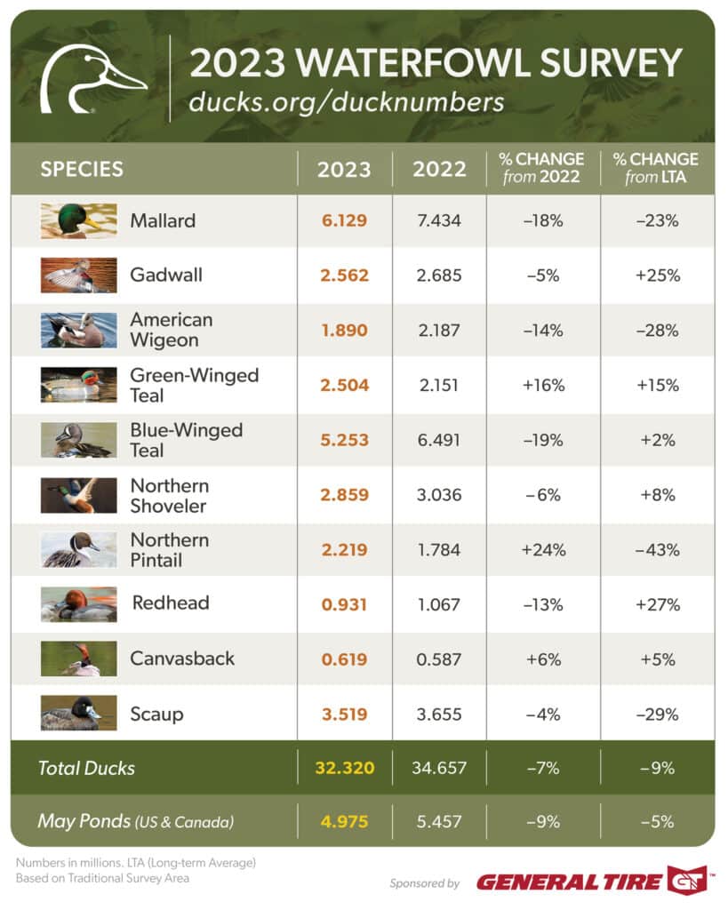
On August 18th, The U.S. Fish and Wildlife Service released its report on 2023 Waterfowl Population Status based on surveys conducted in May and early June by FWS, Canadian Wildlife Service and other partners.

Total populations were estimated at 32.3 million breeding ducks in the traditional survey area, a 7% drop from 2022’s estimate of 34.7 million and 9% below the long-term average (since 1955).

Also included in the report are breeding population estimates for 6 common duck species groups from the Eastern Survey Area, covering eastern Canada and the northeastern states from Virginia to Maine, as well as status updates on populations of geese and swans.

DU Chief Scientist Dr. Steve Adair said the overall numbers reflect a complex relationship between waterfowl, weather, and habitat availability.

“These results are somewhat disappointing, as we had hoped for better production from the prairies following improved moisture conditions in spring of 2022.. Last year’s nesting season was delayed with April snowstorms and May rains, which likely impacted overall production. In the past, we have seen population growth lag moisture conditions as small, shallow wetlands recover from the lingering impacts of severe drought.”

Key Takeaways

  • Populations of most species remain healthy and near the long-term averages, which should produce a respectable flight for waterfowl hunters and waterfowl enthusiasts to enjoy this fall and winter.
  • Total pond numbers in the U.S. and Canada were estimated at 5 million, which was 9% lower than the 2022 estimate of 5.5 million and slightly below the long-term average of 5.2 million.
  • Mallard and American wigeon populations declined. Estimates for mallards were down 18% from 2022 and 23% from their long-term average. American wigeon were down 14% from 2022 and 28% from their long-term average. These declines are a concern for DU scientists and amplify the need for sustained investments in conservation, monitoring, and targeted science.
  • Pintails provided a noteworthy bright spot. Population estimates increased 24% over the record low from last year. Although the survey showed that overall duck populations remain healthy, it also told a story of continuing drought in the western Canadian prairie provinces, which will limit production for ducks that traditionally settle in those landscapes.
  • Subsequent surveys will paint a more complete picture of how well duck populations are recovering from the severe drought of 2020–2021.
  • Highly pathogenic avian influenza – Based on reports from waterfowl managers and wildlife disease experts of partner agencies, DU scientists don’t expect a significant impact on duck populations from the HPAI outbreak of 2022.

“Lower than expected numbers in this year’s survey reinforce the need for wetlands conservation as habitat continues to be lost across the continent,” said Ducks Unlimited CEO Adam Putnam. “For over 86 years, DU has focused on North American wetlands and grasslands that sustain healthy waterfowl populations, and support clean water for people, too. As much as we have accomplished, these data confirm we have more work to do.”

What’s Next

“We remain concerned about the continuing loss and degradation of habitat in the prairies and long-term impacts on carrying capacity and productivity,” Adair said.

Regardless of pond counts and precipitation, waterfowl need productive habitat across their lifecycle to breed, migrate, and winter successfully. Ducks Unlimited, in partnership with the U.S. Fish and Wildlife Service and numerous other governmental, nonprofit and corporate partners, recently surpassed 16 million acres of protected or restored waterfowl habitat.

Ducks Unlimited continues to establish innovative research projects to better understand the needs of waterfowl and better guide conservation efforts. And landowners are a crucial component of healthy landscapes. Farmers and private landowners – with help from voluntary incentive-based programs in the U.S. Farm Bill – can help conservation organizations produce healthier wetlands and grasslands.

The united effort to protect wetlands has paid off over many decades: a recent State of the Birds report shows waterfowl and other wetland-dependent birds are the only species to increase in numbers since the 1970s, primarily because of conservation efforts.

To invest in tomorrow’s wetlands and waterfowl populations, Ducks Unlimited, Ducks Unlimited Canada, Ducks Unlimited de Mexico, and Wetlands America Trust have joined forces to launch Conservation For a Continent, a historic $3 billion capital campaign. Conservation For a Continent is one of the largest North American fundraising efforts to support habitat protection and restoration. Learn more about this effort.

View the full 2023 Waterfowl Population Status report from the U.S. Fish and Wildlife Service.

Source

Ducks Unlimited. (2023). 2023 Duck Population Numbers. Ducks Unlimited. Retrieved from https://www.ducks.org/conservation/waterfowl-surveys/2023-duck-numbers